


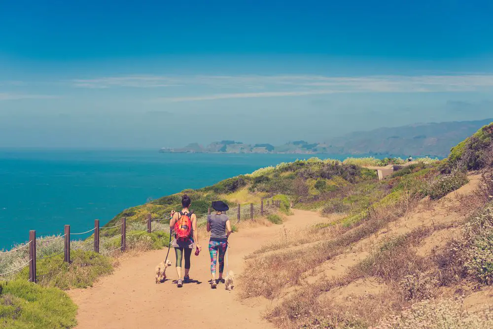
Northern California and the San Francisco Bay area offer amazing trails to explore with your canine companion—and veteran hiker and dog lover Jason Fator has explored 83 of them — here are our top five favorites in and around San Francisco proper.
- Written by Jason Fator
- Photography by B Cruz

South Beach Trail South Beach is a San Francisco treasure — a seemingly untouched beachfront where people can bring their pets, so as long as there are no marine mammals on the beach. If seals are present, the pooch has to stay in the car. This is one of those make-your-own-adventure hikes. Stay close to the parking area on the beach, pull out a blanket for a picnic, and take it easy. Roam the sandy hillsides that are covered with ice plants (blooms of yellow, orange, pink, purple, and red will amaze you).
For the best hike, head to the beach and turn south for about a mile until you come to the sand dunes, stopping every so often to find out what the ocean has brought to shore. When we were there, we found bits of sand-blasted glass, shells and boat floats in several colors. You can even go as far as you’d like on the beach. Some days, it may be just you and your dog on this stretch of beach, where the Pacific meets California. A note about the water: don’t go swimming and watch for rogue waves. The area is known for its tremendous undertow, which will take even the strongest dog paddler out to sea.
Bolinas Ridge If sweeping views and a certain amount of solitude are your idea of a tail-wagging weekend escape, then Bolinas Ridge Trail just might be your cup of tea. The trail is open to hikers, mountain bikers and leashed dogs, of course. The trail starts from a wooden gate and gains 700 feet in elevation in the first 2.5 miles, cutting through rough granite outcroppings as the wide and inviting path inches up the ridge line. To the northwest, enjoy views of Tomales Bay and Point Reyes Peninsula and to the east, Barnabe Peak. At 1.3 miles, you’ll get to a signed trail junction for the Jewell Fire Road. A little farther on, you’ll come to a field with views of Iverness Ridge and Olema Valley. The trail gains its highest point nearly five miles into the trek, where eucalyptus trees stand guard.
But the best place to look around is at the junction with the Shafter Fire Road, where you can scramble up any knoll for great views of Iverness Ridge and the Pacific Ocean. From here, it’s a half-mile to the left to reach Lagunitas Creek, where your dog can cool off and you can get out of the sun and rest in a canopy of dense oak and bay laurel. After a rest and maybe a little lunch, just retrace your steps back to the trail head. A note of caution: the recreation area allows cattle grazing, so make sure to keep control of your dog, as cows can get downright nasty if harassed.
Barnabe Peak Start this hike by crossing Sir Francis Drake Boulevard and walking a couple of hundred yards up an asphalt path along Devils Gulch Creek. Go to campsite 2, turn right, and pick up the slender dirt path signed for Barnabe Peak (you’ll notice the sign, since it is clearly marked that dogs must be leashed). You’ll cross a wooden bridge to the forested side of the creek — for fun, the dogs can splash right through the creek. The trail then climbs out of the canyon and breaks from a canopy of bay laurel, redwoods, live oak, red alder, and the occasional coffee berry and hazelnut. Then it hits you: in the next 2.5 miles, you’ll gain 1100 feet of elevation, while the trail (now a fire road) seems to make an endless zigzag of switchbacks. In the spring, the hills are lush and green, with plenty of California poppy and lupine to admire. Your destination is the rugged stone lookout on Barnabe Peak. As the trail ascends, you’ll get a good look at Bolinas Ridge and San Geronimo Ridge. Once you make it to the top, stop to rest and take in the sweeping, 360-degree views before heading back to your car.
Roys Redwoods Trails Here’s a happy little trail that passes through a pleasant meadow, dives into a darkened forest of giant redwoods, and comes back out again. There’s no “destination” here, just a carefree little jaunt where you’re likely to strike up any number of conversations with people who stop to walk this tiny strip of open space. The trail starts just north of the outhouses. It skirts the meadows just below Nicasio Valley Road and heads beneath Roys Redwoods, home to the towering giants with lightning-scarred trunks. Entering this forest, you’ll see bay laurel and madrone; ferns and poison oak rule the underbrush. Soon enough, the trail breaks from the forest and heads into a mix of grassland and sagebrush that alternates with stands of coast live oak. Take the trail that climbs (stay to the left) at each of the next two junctions. That way, you’ll alternate between rocky outcrops and pretty little meadows that are ablaze with wildflowers in the spring.
Stay on course to a grassy ridge for a look around. The trail now veers east, stays high for a bit, then drops back toward the meadow. The trail loops back into the redwoods, where you will be hard-pressed not to play a little hide-and-seek with the dogs as they sniff around the many delectable scents.
San Geronimo Ridge Residential neighborhoods seem to be closing in everywhere, as the squeeze to fit more people into California (the population is expected to top 54 million by 2050) collides with the needs of people to recreate in clean, green open spaces. Marin County is dotted with open spaces, parcels of land where forward-thinking people decided no development would take place. These would instead be left as places where people could ride mountain bikes, stroll with their dogs, or even get out on horseback. The Gary Giacomini Open Space Preserve is one such place that surrounds the hip town of Fairfax.
Here, you’ll gain about 700 feet in elevation for a nice little workout and spectacular views from atop San Geronimo Ridge. Start on Conifer Fire Road, go past a water tower and through a forest of Douglas fir, bay laurel and live oak. After breaking from the woods, turn southwest for a view of the small community of Woodacre. At the top of the ridge crest, a spur trail wanders north and leads to a striking view of the San Geronimo Valley. I took this trek as the sun was setting, and the ridge made for a rare show as the sun sank toward the Pacific. To the west, you’ll link up with San Geronimo Ridge Fire Road, an old dirt road that travels through a mix of coyote brush and rare Tamalpais manzanita.
Thank You to Our Content Partner
Located in Seattle, Mountaineers Books, publisher of Best Hikes With Dogs series, was established in 1960 by volunteers of the Mountaineers Club to encourage people and their pooches to get out and enjoy the wilds of California and beyond.
Outdoor Gear in the CityDog Shop


RELATED ARTICLES


about the author

Jason Fator
Northern California and the San Francisco Bay area offer amazing trails to explore with your canine companion—contributor to Best Hikes with Dogs: San Francisco Bay Area and Beyond (2nd edition, Mountaineers Books), veteran hiker and dog lover Jason Fator has explored 83 of the ones most likely to satisfy both dogs and their people.
-
This author does not have any more posts.